Backpacking
Massanutten East

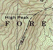
This isn't the most evocative piece of map, but that is the trail crossing of Shawl Gap Trail and Massanutten East/Tuscarora Trails. I hiked up to there from the road via the Shawl Gap Trail and explored 2 miles south and 1 mile north of the intersection. This is in the northeastern corner of the Massanutten/Fort Valley structure.
It was a beautiful day, so I would have enjoyed this even if the walking were bad. It was not bad. I'm continually amazed at how, um, rustic the AT is compared to USFS and NPS trails.
There were some lovely rock stairs on this hike and a great deal of bear scat. There was also a fine view of the Shenandoah Valley and one nice view of the Fort Valley and many peeks through the trees. My guide indicated that it was a moderate hike (+1700 feet in 3 miles, according to my map software) with bad footing. I found the energy rating to be correct, but I found the footing to be good and the trail well maintained.
Before this hike, I'd crossed the Tuscarora Trail, but never hiked on it. I'm really curious what the "experienced hikers only" part of the Tuscarora Trail looks like. At the time of this writing, deer season is upon us. It will not happen this year as I will be retreating into SNP to avoid hunters. The gunfire makes me really nervous, blaze orange or no. I have no idea if I need to be or not, but that's not on my list of approved ways to die -- that I know.

![]() October 27, 2001 ~ 6.5 miles ~ Kennedy Peak
October 27, 2001 ~ 6.5 miles ~ Kennedy Peak
It snowed. It had been 90' on Wednesday, and on Saturday, it snowed. How cool is that!?
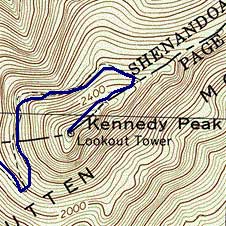
I took the Massanutten East Trail from Camp Roosevelt to the Kennedy Peak trail and hiked up to the observation tower. My software tells me this is an 1810' elevation change, but it's built properly and is very rewarding for the minimal amount of work.
Even without the snow, it was a good hike. It seems to me that the footing on the Massanutten Trails is rugged, but not as rugged as the A.T, so I would rate the treadway as good. The only problems I had were the leaves in the lowest section just above Camp Roosevelt. They hid the rocks so I could not place my feet effectively, and my ankles took a lot of twisting until I got up to about 1800'. About the same time as the snow started. I did not have the place to myself. There were people all over the place. There were hunters scouting for next week, there were people just out of their cars with no supplies at all and there were horse campers too.
After that, there is the typical little ups and downs of a ridge line until you approach Kennedy Peak and do some more up. At that point, there is a white blazed trail to the shelter and tower, which is a really cool little building and well located to boot. I'd love to camp there some time, but it would have to be at an odd time to avoid people. As soon as I got to the shelter, it stopped snowing, and there was an excellent view of the Shenandoah Valley. There is also a Fort Valley overlook before the peak trail.
February 21, 1998 ~ unknown distance ~ Duncan Hollow Trail
Duncan Knob is one small bit of the Massanutten Mountain area. There are numerous hikes to take from FDR 274 (Accessible via I-81 to New Market, Route 211 East) including climbing Duncan Knob, circuits involving the Middle Mountain Trail, Duncan Hollow Trail, Gap Creek Trail and Scothorn Gap Trail. If you're willing to walk the FD road, you can also make a circuit of the Duncan Hollow Trail and the Waterfall Mountain Trails.
We were going to go in at Scothorn or Gap Creek and climb Duncan Knob, camping at the bottom of it in Peach Orchard Gap. Since the parking areas were full at both the Scothorn and Gap Creek trail heads, we decided that we'd go see what Camp Roosevelt was. This is a developed area for family camping that was build by the CCC during the WPA days. The trail head for Duncan Hollow is nearby, and since Camp Roosevelt was closed, it was quite deserted. We hiked in from there, and we didn't see anyone else until we were coming out. They were going in.
The DHT is quite well travelled. We saw horse prints, but no horse campers. From some areas of the trail, private properties are visible lower in the hollow. I doubt you'd be able to see them in the summer, but they are there. We also heard some shots, indicating that there were hunters in the area. Nothing on this trail was particularly notable for Virginia, not the parts we saw anyway. There was a *very* large campsite about .1 miles in. We found a nice campsite about 1 mile in and we ate lunch there. There are numerous water crossings, and one serious one right before the campsite where we ate lunch. Right after it, there is a juncture with a old jeep trail, and the Duncan Hollow Trail continues at that width.
Tino decided that he wasn't into this winter stuff, so we backtracked to the car. We then decided to camp further back on FDR 274. We'd seen many turn-offs for informal car sites, and we found a nice one next to a very loud babbling creek, which I found soothing. Nothing terribly eventful happenned, but this was really an experiment to see if we could deal with winter camping (it only got down to about 32 that night). I was OK with it, but Tino was not.
Since he didn't get any sleep, we decided that trying to climb Duncan Knob on Sunday might not be a good idea. We took a different route home so that we could use Skyline Drive, but since it was closed, that didn't work too well. There is, however, a *stunning* overlook on top of Massanutten Mountain on Route 674 with a pastoral view of the Shenandoah River Valley. Unfortunately, some assholes have left their old beer cans and fast food containers on the slope down from the overlook. We packed out quite a few beer cans and other garbage from the camp site, but this was way beyond anything we could hope to rectify. If you didn't get out of the car, you might not notice. If you do get out, don't look down at the slope, lest you spoil the experience of the view. We were there very early in the morning, which make all the water down there sparkle.
Appalachian Trail | AT Journal | AT Resources
